|
North-East Diary
|
| Front Page |
|
Explanatory
|
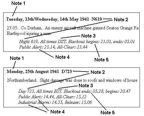
A double date indicates the the event(s) occurred between 18.00 on the first date and 06.00 on the following morning. Double dates are used even where the entire event occurred before or after midnight. This convention was adopted for many official reports in World War Two.
A single date indicates that the event(s) occurred between 06.00 and 18.00 on the day in question, or that no date is known for the events.
Day numbers (e.g. "Day 723" or "D723") are used with single-date entries. This is the "Day of the War" count calculated from Day 1, Sunday, September 3rd 1939.
Night Numbers (e.g. "Night 619" or "N619") are used with double-date entries and idicate the 12-hour period beginning at 18.00 on the day in question.
Day and night numbers of the form "Dxxx" or "Nxxx" are used for indexing purposes.
The table below shows the range of day numbers for each month of the war.
GMT and BST need no explanation, but DST or Double Summer Time was also used during the war. This was GMT + 2 hours. See also Background Information - Section 20
All times in this diary use the appropriate Civil Time for each date and are in standard 24-hour format:-
| Midnight | = | 00.00 |
| 6 am | = | 06.00 |
| Noon | = | 12.00 |
| 6 pm | = | 18.00 |
The times of the Public Alerts (the sirens) and the All-Clears. Unless otherwise stated these apply to the "Newcastle Warning District" which covered Tyneside, Wearside and parts of Northumberland and Durham. All the sirens in a given Warning District sounded at the same time (within a minute or two) but other Warning Districts could have quite different times. The neighbouring Warning Districts were Berwick, Hexham, Bishop Auckland and Middlesbrough. (Morpeth was added in 1943). Instructions to sound the sirens were given by RAF Fighter Command.
Industrial Alarms were issued to some factories and other large institutions when air attack was considered imminent. In such premises the workers would ignore the sirens and only seek shelter when bells or klaxons told them that an Industrial Alarm was in effect. The times given here apply only to premises in Newcastle itself.
The blackout times for the Newcastle area. These times were related to sunset and sunrise times and therefore varied slightly across the region.
| 1939 | 1940 | 1941 | 1942 | 1943 | 1944 | 1945 | |
|---|---|---|---|---|---|---|---|
| Jan | 121-151 | 487-517 | 852-882 | 1217-1247 | 1582-1612 | 1948-1978 | |
| Feb | 152-180 | 518-545 | 883-910 | 1248-1275 | 1613-1641 | 1979-2006 | |
| Mar | 181-211 | 546-576 | 911-941 | 1276-1306 | 1642-1672 | 2007-2037 | |
| Apr | 212-241 | 577-606 | 942-971 | 1307-1336 | 1673-1702 | 2038-2067 | |
| May | 242-272 | 607-637 | 972-1002 | 1337-1367 | 1703-1733 | 2068-2098 | |
| Jun | 273-302 | 638-667 | 1003-1032 | 1368-1397 | 1734-1763 | 2099-2128 | |
| Jul | 303-333 | 668-698 | 1033-1063 | 1398-1428 | 1764-1794 | 2129-2159 | |
| Aug | 334-364 | 699-729 | 1064-1094 | 1429-1459 | 1795-1825 | 2160-2190 | |
| Sep | 1-28 | 365-394 | 730-759 | 1095-1124 | 1460-1489 | 1826-1855 | |
| Oct | 29-59 | 395-425 | 760-790 | 1125-1155 | 1490-1520 | 1856-1886 | |
| Nov | 60-89 | 426-455 | 791-820 | 1156-1185 | 1521-1550 | 1887-1916 | |
| Dec | 90-120 | 456-486 | 821-851 | 1186-1216 | 1551-1581 | 1917-1947 |
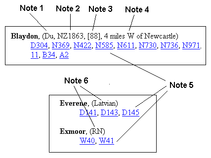
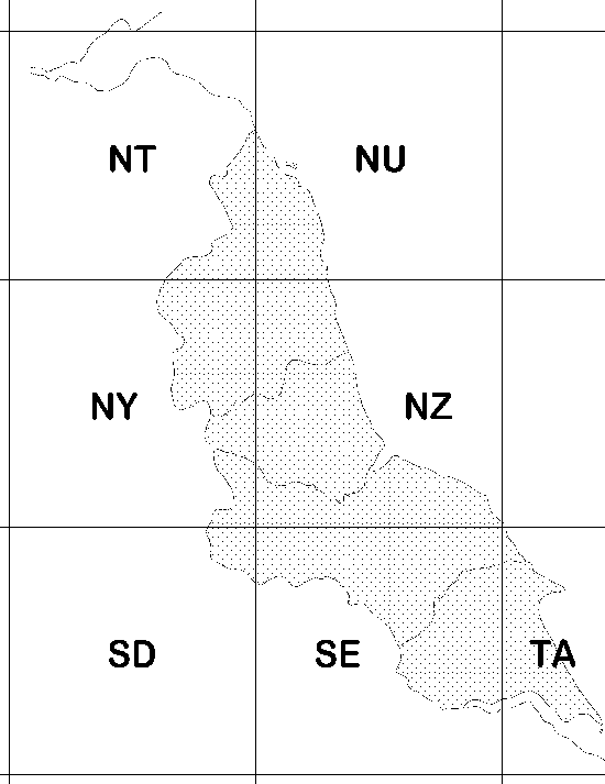
County:- Nd = Northumberland, Du = Durham, Yk = Yorkshire, La = Lancashire
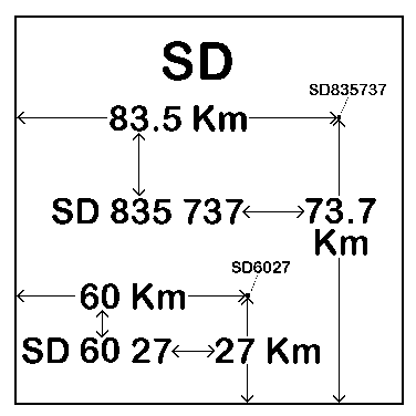
Ordnance Survey four-figure grid reference. (See map and diagram below).
Ordnance Survey Landranger series sheet number(s).
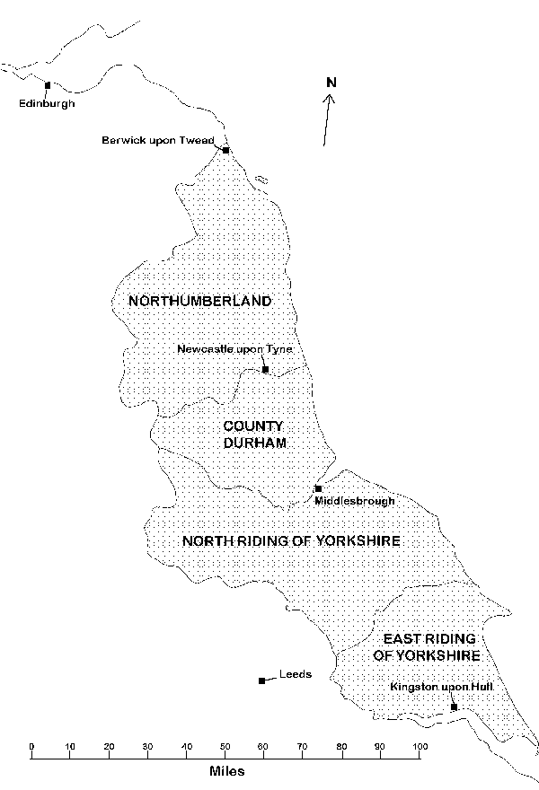
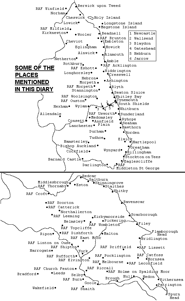
Distance and approximate direction from the nearest of the six "reference" towns. (i.e. Edinburgh, Berwick, Newcastle, Middlesbrough, Leeds and Hull - see map below).
Hypertext links to sections, paragraphs or tables containing references to the place or ship.
Entries of the form:
"D---" or "N---" refer to Day or Night numbers in the main body of the diary. See Part 1, Note 2 and Part 2 above.
"A---" refer to the "Acknowledgements" page.
"Ab---" refer to the "Abbreviations" page.
"B---" refer to the "Background" pages.
"E---" refer to the "Other Events" page.
"F---", "FD---" and "FN---" refer to the "Firsts" page.
"I---" refer to the "Introduction" page.
"P---" refer to the "Post-War" page
"W---" refer to the "Warships Launched or Completed by N.E. Shipyards" pages.
Nationality of the ship. British ships are denoted by either "MN", meaning "Merchant Navy" or "RN" meaning "Royal Navy" ("RN" includes merchant ships requisitioned by the Admiralty).
This index contains the names of warships from battleships to tugs, including battle-cruisers, aircraft carriers, fighter catapult ships, cruisers, minelaying cruisers, destroyers, frigates, corvettes, sloops, submarines, experimental mine destructors, controlled minelayers, motor launches, motor gunboats, tank landing ships, cable ships, fleet oilers, fleet tugs, minesweeping trawlers, coastal salvage vessels, drifters, blockade runners, auxiliary patrol vessels, harbour defence vessels, mooring vessels, motor anti-submarine boats, boom defence vessels, auxiliary patrol trawlers, gantry landing ships, barrage balloon vessels, submarine accommodation ships, aircraft component repair ships, aircraft maintenance ships, coastal forces depot ships, trawlers, even paddle minesweepers. The index contains vessel names only, vessel type descriptions are to be found in the diary
The categories of merchant ships include passenger liners, cargo ships, oil tankers, colliers, ferries, hopper barges, tugs, trawlers, oil barges, . The Admiralty commandeered many merchant vessels during the war but those mentioned here are generally thought to be sailing under the Red Ensign or in the case of foreign vessels, their respective merchant ship flags.
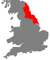
The main area of interest is shaded.
| Front Page |
![]() © Copyright
Brian Pears
1994-2011
© Copyright
Brian Pears
1994-2011